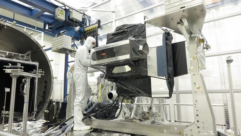
At the end of August, the German Aerospace Center (DLR) handed over its latest innovation for precise weather forecasts to the European Organization for the Exploitation of Meteorological Satellites (EUMETSAT) and the European Space Agency (ESA): The METimage multispectroradiometer can measure clouds, ice cover, surface temperatures of land and oceans, vegetation and fires from space with unprecedented accuracy.
METimage will be launched on the Metop-SG satellite in 2025. From an altitude of 830 kilometers, the system will scan a 2,670-kilometer-wide strip of ground every 1.7 seconds at a resolution of 500 meters per pixel. In this way, it will cover the entire Earth's surface in one day. The data can be used to predict extreme weather events such as storms and heat waves earlier and more reliably.
Dr. Walther Pelzer, Director General of the German Space Agency (DLR), points out: "In order to be able to react to the consequences of climate change, we are dependent on precise Earth observation and weather information. Satellites play a key role here. In the future, METimage will provide important data for global climate models in order to take the right measures to combat the effects of climate change".
The German Space Agency at the German Aerospace Center DLR led the development and construction of METimage, while the aerospace group Airbus implemented the project. Two further radiometers are under construction.


